Melbourne Airport (MEL)
City Orientation and Maps
(Melbourne, Victoria (VIC), Australia)
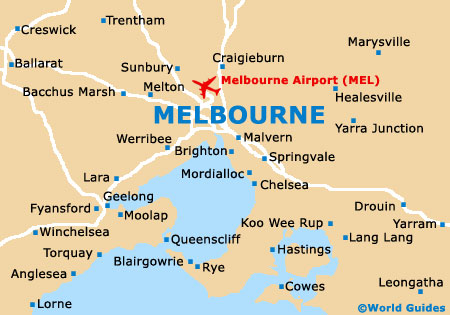
The city of Melbourne is located on the southern side of Australia, in the state of Victoria, in between both Canberra - to the north-east, and Adelaide - to the north-west. Melbourne is an appealing city and is situated alongside the Bass Strait and the Indian Ocean, with the island of Tasmania lying directly south and the Tasman Sea to the east. Melbourne Airport (MEL) can be found on the northern side of the city, next to Gellibrand Hill Park, in the Craigieburn area.
The city's southern suburbs stand around Port Phillip Bay, while the actual city centre is situated alongside the northern banks of the Yarra River. Central Melbourne sits to the west of Fitzroy Gardens, to the south of Victoria Street, and to the east of Spencer Street. The western side of the city has changed greatly in recent years, with Melbourne's impressive docklands area dominating much of this neighbourhood.
The very centre of Melbourne is laid out as a gridwork which stretches for around 1.6 km / 1 mile by 1 km / 0.6 miles. This area was previously known as the city's 'Golden Mile' and the main thoroughfares here include both Collins Street and Bourke Street. Regular buses travel both to and from Melbourne Airport to the nearby Spencer Street coach station.
Melbourne Airport (MEL) Maps: Important City Districts
Many of Melbourne's inner suburbs have been redeveloped and renovated in recent years and include numerous important neighbourhoods, such as Carlton, Collingwood, Fitzroy, Prahran, Richmond, South Yarra, Southbank, St. Kilda, Toorak and Williamstown.
Australia Map

Victoria Map

Melbourne Map